STOP #11
CRAMPTON'S GAP SIGNAL STATION |
This station was
occupied on 8 July by Lieut. George A. Fisher, who was directed here by Capt.
Nicodemus. It had little utility as a station of communication or as a station
of observation. Lieut. Fisher was forced to move further up the ridge in order
to communicate with the necessary stations. The high ground you observe'd on
the left as you drove up the mountain is the area to which Fisher relocated
his station. Lieut. Fisher explains in his report.
Report of Lieut. George A. Fisher, Acting Signal Officer,
Washington Reserve Signal Party
Captain:
I have the honor to submit the following report of duty
performed since July 6, 1863.

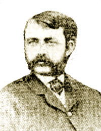
George A. Fisher |
|
On the evening of the 6th, was ordered to precede the main party, with
Lieutenants Herzog and Rushby, and with our men accompany and guard the
wagon train to Frederick, Md., where we arrived on the 8th instant, and
immediately reported to you at your headquarters. About an hour afterward I
received orders from you to proceed without delay to Crampton's Gap, in the
South Mountain Range, and open communication with Middletown, Maryland
Heights, and South Mountain, if possible, and take observations of the
movements of the enemy. I endeavored that evening to open communication, but
was unable to find a point where I could see more than one of the stations,
and after calling Maryland Heights for some time, was obliged to give it up
for the night. Early next morning I moved across the gap, and proceeded
along the ridge about 3 miles, and selected a station from which, with some
labor, I was enabled to communicate with both Middletown and Maryland
Heights, .thus completing the line of stations between Maryland Heights and
Hagerstown.
On the 12th instant, Captains [Joseph] Gloskoske and [Richard] Dinsmore
received orders from Captain Norton to close up the station at Middletown
and rejoin his command. I was then obliged to find some other station with
which to keep up the line of communication, and was enabled to do so with
Lieutenant Briggs, who was at Elk Ridge, in communication, with South
Mountain. Owing to the state of the weather, for the most of the time we
were unable to take many observations, but embraced every opportunity that
presented itself ...
[O.R., XXV-II, Part I,-pp. 213-214.]
As evidenced by the movement to establish line of sight with other stations
described in Lieut. Fisher's report, it does not appear that maps were used to
establish line of sight profiles for the potential signal stations. This was
probably due to the lack of maps with sufficient contour detail as well as the
fact that the art simply had not progressed that far. There is no mention of
the use of maps for this purpose in Col. Myer's A Manual. Col. Myer's visual
method for establishing signal stations is as interesting as it is intricate.
It is described in his manual as follows:
To open a line of stations across a country, first choose some
prominent position, and one well visible; and here establish the initial
station. Let the party assemble here. Let them, together, select a second
prominent point in view as nearly as possible in the line of direction you
wish to take. Upon the first station, erect some kind of beacon - as a white
or other colored signal-flag; or some marked object, by which it can be
recognized from a distance. Take from this first point the bearing by
compass of the point selected. This second point should be one not only
visible from the initial point, but one also probably in view from positions
beyond it. Note should be made of some peculiar house, rock, tree, or other
marked object upon it, in order that the exact place may be recognized when
it is reached. At the first point, now marked with its beacon, station an
officer to reply to any signals he may see, and to watch the course of the
marching party. The other officers will then move, guided by compass, if
need be toward the second point selected, carrying a signal-flag flying, in
order that their position may be known whenever they come in view from the
first station, and intently watched by the officer left at that station, the
marching party will, from time to time, put itself in communication with the
first station, so as to receive from it any direction as to its course the
first station may wish to give, or any other information. It will also
frequently verify its course by compass. On reaching the point chosen for
the second station, a beacon or flag will be there erected, observations
will be made, and communication will be opened with the first station.
Points, on either side or to the rear, will be examined, to see if the
second station can be better located than it is with reference to a third
station to be next established. The second station will then be definitely
established and marked, and an officer there stationed, as before at the
first station, to watch the marching party. The point for the third station
will be hence chosen,. and the party will proceed toward it with the same
general rules as before. These operations will be repeated in the case of
each rminal station is reached. station, until the te Attempts will be
afterward made to reduce the number of intermediate stations by finding
other and better points at which to locate some of them.
Now you should drive to STOP 12.
Go back down GAPLAND ROAD and turn right on ROUTE 67. Drive 5.4 miles and
turn LEFT on MT. CARMEL CHURCH ROAD. Drive 0.3 miles and it turns into
DOGSTREET ROAD- Continue for 2.1 miles and turn LEFT on RED HILL ROAD. You are
now on ELK MOUNTAIN. Drive 1.2 miles and stop in the parking lot of the
MCCLELLAN GUN CLUB.
|


